Date: November 2012
Destination: Redding, California
Miles from Mart, TX:1,960
Redding,
California is
located in the north end of the Sacramento Valley, in Shasta County.
The population is approximately 89, 861. Redding
is halfway between Mexico and Canada.
The biggest employers are hospitals, state and local governments. It
was formed in 1887 with 600 people. Copper, iron, and cinnabar mining
were the
main industries by 1910. Redding is also
a tourist area with two very large lakes. The average temperature in
January is 46 degrees and in July it’s 82
degrees.
 |
| Flat
Kinsey visited my Aunt Miriam's mom, Catherine, and her husband, Ramsey,
in Redding, California. Below are a few pictures they have sent me of
their adventures with Flat Kinsey. |
 |
| Flat Kinsey at Catherine's favorite Italian restaurant. |
 |
WOW! Look at that delicious California pizza!
 |
| Ran some errands with Ramsey today. Gas in California is $3.59 a gallon! That's about 59 cents higher than Waco! Glad we live in Texas! |
 |
| They
ate at his favorite restaurant, which serves Greek food. It looks like
Flat Kinsey ate some too. She has some yogurt sauce from the gyro on
her face! Ramsey said she had some coffee too and was up all night!!! |
 |
| Next
they went to the bank. Flat Kinsey got to ride in a tray where you put
your deposits at the bank. The bank tellers were so kind and held Flat
Kinsey for a picture. |
 |
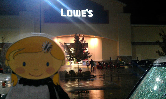
| Finally, they stopped by Lowe's and Home Depot looking for a new hose for their dishwasher. It was raining!!! |
 |
| Copley Mountain is a mountain summit in Shasta County, California. Copley Mountain climbs to 2,927 feet above sea level. |
|
 |
| Ramsey took Flat Kinsey for a little off road adventure. This is Angus! Ramsey said he is a big baby! LOL!!! | |
|
 |
| Ramsey didn't have a car seat so he buckled Flat Kinsey in for the ride! |
 |
| They got stuck, but Ramsey saved the day. Neither of them were ready to stay the night outdoors! |
 |
| Flat Kinsey loved seeing the beautiful mountains!!! |
.JPG) |
This is the Sundial Bridge in Redding. It has a frosted glass
deck and beautiful Spanish tile. The bridge has a very unique design. The 217-foot
pylon acts as a sundial, which tell time on a tile covered garden border on the
north side of the bridge. The designer was Santiago Calatrava. To him the bridge resembles a bird in flight.
The bridge was completed in 2004. The 217 foot mast points due north at a cantilevered angle, allowing it to serve as
the pointer of a sundial; it has been said to be the world's largest sundial. The Sundial Bridge pointer's shadow is cast upon a large dial to
the north of the bridge, although the shadow cast by the tower is
exactly accurate on only one day in a year – the summer solstice, June 20 or 21. The time is given as Pacific Daylight Time.
The tip of the shadow moves at approximately one foot per minute so
that the Earth's rotation about its axis can be seen with the naked eye.
|
.JPG) |
| If you look real closely you can see a lightening rod at the top of the structure. |
.JPG) |
| A sundial is an instrument showing the time by the shadow of a pointer cast by the sun onto a plate marked with the hours of the day. The sun passed over these two markers while we were visiting the bridge. |
.JPG) |
Ramsey is walking on glass!!!!! They were going to make the glass clear, but someone decided at the last minute that people might get scared if they could see the water moving below their feet. When people are walking on it you can feel the bridge move. Scary huh? See the big cables? They will move if you shake them.
|
 |
| This is the view from the Sundial Bridge. The Sacramento River runs under bridge. |
.JPG) |
| This is the Kennedy Memorial Plaque at the Whiskeytown Dam. |
.JPG) |
| Ramsey recorded President Kennedy's speech, but it was difficult to hear. |

.JPG) |
Wiskeytown was a popular
mining town during the Gold Rush era. It
is now under water. The Whiskeytown Dam is
the home of the “glory hole.” The "Glory Hole" is a giant drain. Water spills over its lip when the lake reaches 1,602,000 acre-feet. The
funnel's largest diameter is 72 feet and narrows to about 28 feet. It
is designed to handle a maximum of 362,000 gallons of water per second,
which occurs when the lake level rises to 15.5 feet above the level of
the funnel.
President John F. Kennedy
greeted more than 10,000 people on September 28, 1963 at the Whiskeytown Dam
dedication. Water from the dam was intended to provide irrigation water to the
Central Valley.
|
.JPG) |
| Picture of the Whiskeytown Dam. |
.JPG) |
This is what they call the "Glory Hole". |
 |
| Picture online of the "Glory Hole" in action. (Uploaded by CarlMcCabe) |
 |
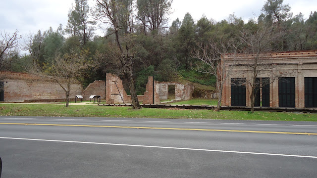
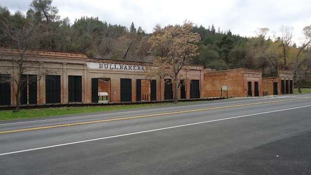
| This is Shasta State Park, also referred to as "Old Shasta Town." In 1850, Shasta was the center of Northern California.
Temporary camps, tents, and shacks turned into permanent residences. It
became a "town" with hotels, stores, and saloons. You can visit ruins of remaining buildings and imagine what it was like to live there during the "Gold Rush." The "Gold Rush" brought people to the area, seeking
their fortunes. A couple of initial settlements grew together into a
"town," but a couple of big fires soon led to the construction of the
"fireproof walls" and Iron Shutters.
|
.JPG) |
Restored Old Shasta Bakery Building
There is also an old jail that has now been turned into a museum. The jail cells are downstairs and have mannequins dressed up as bad guys in the cells.. |
.JPG) |
|
Old Shasta Fireproof Buildings from 1852
|
.JPG) |
|
More Old Shasta Fireproof Buildings from 1852
|
.JPG) |
| Old Shasta Masonic Building
|
 |
| Old Shasta Courthouse Museum opened in 1950 |
.JPG) |
| We visited the Tuscan
Heights Lavender Gardens. It is located on the mountain side in Whitmore, California in the Shasta
Cascade Mountain Range, 35 miles east of Redding, California. It smelled soooooo good! The
Tuscan Lavender is a great producer of essential Lavender oil and
is one of their main plantings. It produces one of the
sweetest smelling oils distilled. Tuscan Oil is what they use
when making some of the products they sell, such as, organic bath and body
products. |
.JPG) |
| This is Richard. He is making oil from the lavender plants. |
 |
| This dog belongs to one of Ramsey's friends. The dog's name is KINSEY! |


.jpg)


.jpg)


.JPG)


.jpg)

.jpg)
.jpg)
.jpg)


.JPG)
.JPG)
.JPG)
.JPG)
.JPG)
.JPG)

.JPG)
.JPG)
.JPG)

.JPG)
.JPG)
.JPG)
.JPG)
.JPG)
.JPG)
.JPG)
.JPG)


.JPG)
.JPG)
.JPG)
.JPG)

.JPG)
.JPG)
.JPG)
